Our Business.
A promising top tier African gold explorer, developer and major producer.
Over 70 million tons of gold mineral resources deposits in the Kingdom Coin Mining Aboso Gold Mine
Increased tax cashflow for the Ghana Revenue Authority.
Impressive Increased Dividends Cashflow Payable to Investors; Shareholders
Improved Corporate Social Responsibility Endeavors; Contributions to host Communities.
Our operations secure overs 85% local Employment opportunities for host communities
Location and Environment .
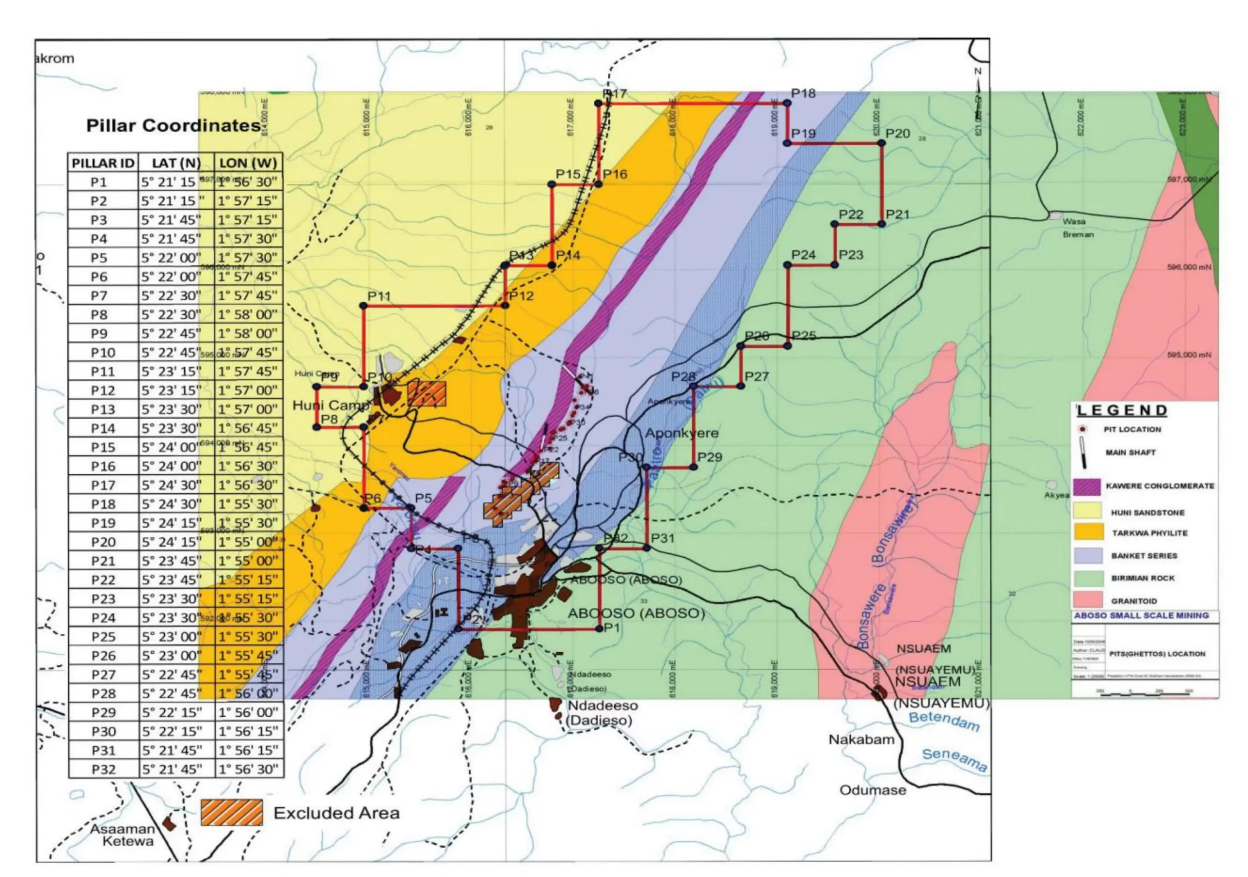
The Kingdom Coin Mining’s Aboso Gold Project (AGP) is a concession covering 16.07km2 (77 blocks) in the Western Region of Ghana. Aboso (estimated population of 20,000) lies within the concession. The project is 190- 200 km northwest of the Capital City of Accra and 55 km northwest of the port city of Takoradi. The major (asphalt) arterial road, grid power and rail link (inactive) cross the property. The largest town in the area is Aboso (approximately 25,000 population) but both Huni Valley and Damang further to the north of Aboso are substantial villages (each with a population of over 1000 people).
Population & Major Economic Activities .
Most of the population is involved in small-scale mining. Aboso is proximal to major mining centres namely the Prestea, Bogosu, Damang, Teberebie and Tarkwa mine operations. The principal land use within these communities is farming and small-scale mining which has been the mainstay for the people of the aforementioned communities. However, significant portions of these lands have been deployed historically for licensed mining and illegal small mining activities due to the land’s very fertile minerals (gold) deposits.
Regional Geology.
The gold deposits of West Africa largely lie within the Proterozoic domain of the Man Shield, the southernmost subdivision of the West African (or Guinean) Craton. Lithologies comprising the shield overlie the largely unknown Archaean Liberian Craton. The Man Shield represents approximately 45% of the exposed geology of Ghana, being largely restricted to the northern, western and southwestern portions of the country. The shield area is confined to the southeast by a Proterozoic mobile zone, while the central-eastern portion of Ghana is veneered by late Proterozoic to early Palaeozoic sediments of the Volta Basin.
The Precambrian Birmian System of West Africa can be broadly subdivided into phyllites, tuffs and greywackes of the Birmian metasediments, and various basaltic to andesitic volcanics and volcaniclastics of the Birmian metavolcanics. These subdivisions are largely believed to be coeval and have been deformed and regionally metamorphosed to grades ranging from lower greenschist to lower amphibolite facies.
The principal gold producing areas of southwestern Ghana, are associated with the coeval Lower Proterozoic Systems of the Birimian (2.17-2.18 billion years) meta-volcanic (arc) and metasedimentary (basin) rocks, along with the younger, unconformably overlying Tarkwaian epiclastic system, developed within and along the margins of the Kumasi Basin. Erosion of the volcanic arcs during arc/basin development produced the argillites, turbidite units and tuffs of the Kumasi Basin.
The Birmian System has been intruded by two distinctive granitoid types. The larger basin-type granitoids (and gneisses) of the Cape Coast Suite are muscovite and/or biotite- rich, distinctly foliated and deformed, and present a pre-tectonic appearance. The smaller belt-type (arc related) granitoids of the Dixcove Suite on the other hand, are hornblende-rich, lack the characteristic foliation of the former, and are generally interpreted to be syn or post-tectonic. Despite their appearance, the belt-type granitoids are dated as being 60-90 million years older than the larger basin-type granitoids, however these dates are frequently inconsistent with field observations.
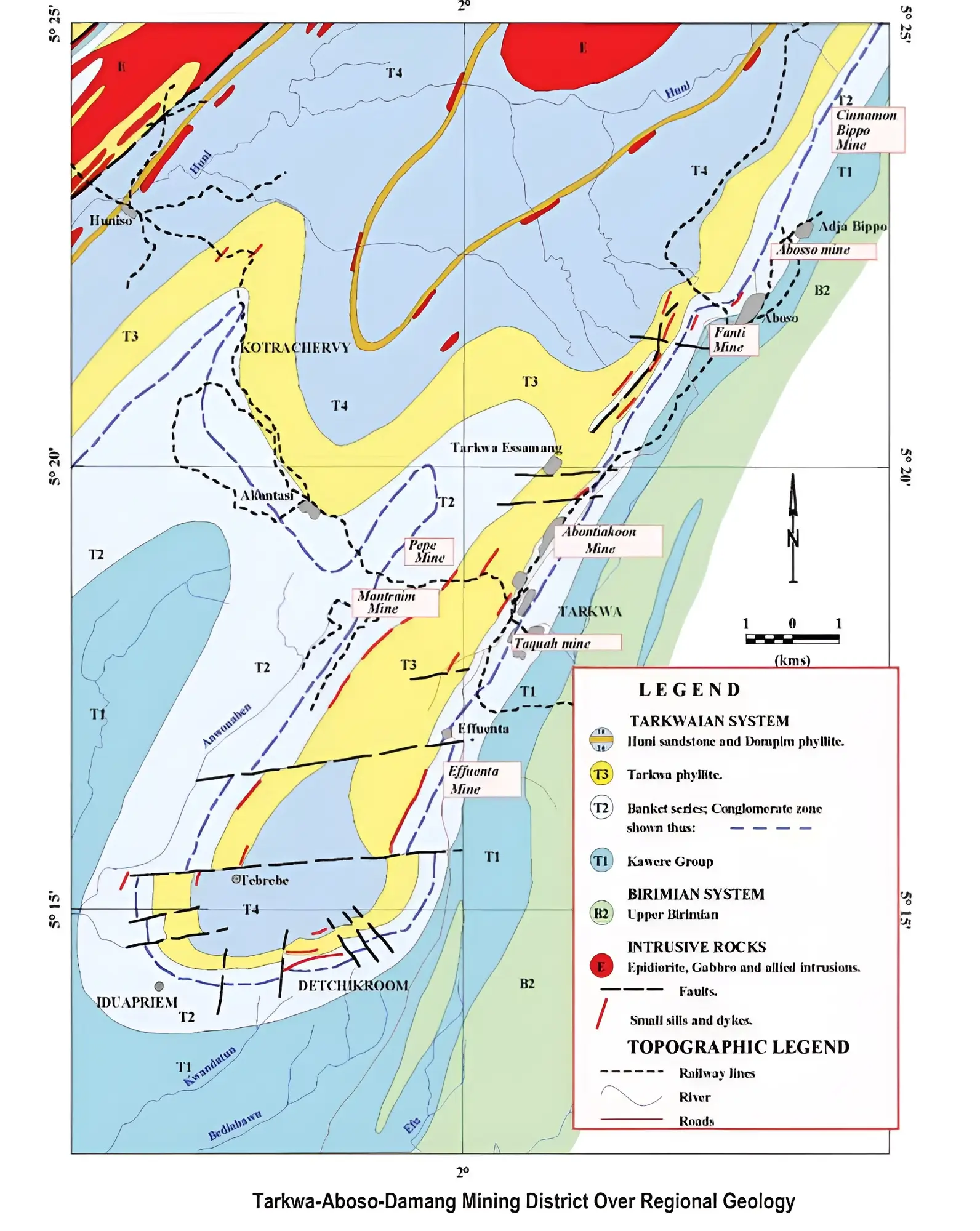
The younger Proterozoic Tarkwaian sediments, thought to unconformably overlie the Birimian System, consist of a thick series of arenaceous, and to a lesser extent argillaceous sediment, believed to be derived from erosion of the Birimian. Economically important conglomerates and quartzites, termed the Banket Group, comprise the basal portion of the series. The Tarkwaian Series is largely confined to elongate north-northeast trending basins, believed to represent intra-cratonic rifts. The margins of these basins commonly coincide with major (frequently mineralised structures representing the contact between Birimian metavolcanics and Birmian metasediments sequences. It is conceivable that reactivation of the major structures during a period of crustal extension, may have been responsible for rifting, and subsequent preservation of the Tarkwaian Series (Fig. 3).
The Birimian belt-basin development was followed at around 2.1 billion years by the Eburnean tectono-thermal event, a single-stage progressive SE-NW compressional and regional metamorphic episode, expressed by foliation and shear development oriented between 025° and 050°. Metamorphic grade is generally lower greenschist facies with higher-grade facies developed locally, particularly proximal to intrusive bodies. Isoclinal folding (foliation, oriented NNE-SSW) is regionally well developed in the argillaceous faces. Multiple episodes of strike-slip and over-thrust faulting from the northwest (and perhaps the southeast in part) are more apparent in the arc-related Birmian volcanics and Tarkwaian Series.
The Birimian Series of West Africa is host to some of the largest gold deposits in the world, including Sadiola, Yatela, Morila and Syama in Mali, Obuasi, Bogosu, Prestea and Bibiani in Ghana, and Siguiri and Lero in Guinea. The spatial distribution of gold mineralization in Ghana is closely governed by north to northeast trending belts of metavolcanic rocks comprising the Birimian metavolcanics, which range from 15km to 40km in width. Almost without exception, the major gold deposits lie at or close to the margins of the belts in close proximity to the strongly deformed contacts between the Birimian metavolcanics and Birimian metasediments sequences. Gold mineralization in Ghana is found in three principal settings.
The most significant of these deposits are closely related to major structures at the Upper and Lower Birimian contact. Deposits are of numerous styles, including quartz reefs hosted within frequently carbonaceous phyllites and greywackes, associated with major semi-conformable shear structures and subsidiary oblique faults. Lower grade mineralization may also be present as disseminations or associated with sheeted quartz veining within tuffs. greywackes and mafic dvkes situated in close proximity to major structures. The second style of gold mineralization is that associated with sheeted vein swarms and stockwork zones within granitoids. These deposits are typically lower grade than the reef style mineralization and appear to be confined to the smaller belt-type or Dixcove Suite granitoids and their regional equivalents. Banket deposits represent the third significant style of mineralization, hosted by quartz pebble conglomerates towards the base of the Tarkwaian Series. The gold is thought to be of detrital origin, derived from erosion of the Birmian Series upon which the Banket Group lie. Epigenetic sheeted or stockwork quartz veining is, however, also present within lower portions of the Tarkwaian Series.

Local Geology.
Bedrock gold occurrences in this Tarkwa-Aboso district are hosted mainly by a distinctive quartz conglomerate with considerable lateral extent. The Tarkwaian paleoplacers are hosted in a thick sequence (Tarkwaian Group) of shallow water metasediments that occur in a broad belt covering much of the Ashanti Belt. Most of the known occurrences, and certainly the most important ones, occur in the immediate vicinity of Tarkwa and Aboso.
The total thickness of the Tarkwaian is quite variable but generally in the order of 2000-2500m. The lowermost unit (Kawere Conglomerate features polymictic conglomerates with abundant interbedded argillaceous sandstones, quartzites, and sedimentary breccias. The coarse units include clasts of quartz, mafic volcanics, phyllites and minor red chert and porphyry, which is described by Hirst (1938) as resembling the porphyry associated with the Dixcove granites.
The Banket Series is generally conspicuous because it is often resistant to weathering and therefore forms ridges and hills. The series is dominated by pale grey quartzites and cross-bedded sandstones. The conglomerates are essentially oligomictic and feature pebble to small boulder sized white quartz class (usually matrix supported but sometimes clast supported) in a matrix of siliceous material and commonly containing fairly abundant iron oxides (black sands). These conglomerates, or banket units as they are commonly called, are important because they host the extensive gold deposits, which are generally concentrated in the lower conglomerate units.
Overlying the Banket Series is the Tarkwa Phyllite, which is gradational with both the underlying Banket units and the overlying elastics of the Huni Formation. The Tarkwa phyllites are variable in thickness (about 120-400m in different parts of the district but can be traced over wide areas.
The uppermost Huni Formation is by far the thickest (approximately 760m or 2500 ft of the formations comprising the Tarkwaian Group. It is dominated by grey to blue-grey phyllites and a variety of quartzites and sandstones with some evidence of cross-bedding structures; these units typically weather to various shades of light green.
The district is characterized by broad, generally open folds well displayed in a series of approximately NNE to NE trending synclines and anticlines that can be traced across the 20km wide strip from Tarkwa to the Prestea area. In the Tarkwa district, these structures are fairly open with dips commonly in the 30-45° range but there can be substantial variations along strike.
Faulting is quite extensive in the area and generally features two dominant types. The one type, called 'overlap' fault, is commonly observed in most of the old underground mines and consists of steeply dipping reverse faults parallel to the strike of the sediments. These commonly cause a repetition or structural thickening of mineralized banket horizons.

Gold Mineralization.
Most of the known gold occurrences, and certainly the most important ones, occur in the immediate vicinity of Tarkwa. On the eastern margin of the Tarkwa syncline, the high-grade gold is confined to a relatively thin (0.5 to 6m) band of conglomerate but towards the west the conglomerates thicken up and split into several horizons, all of which contain some gold.
Early production came from the high-grade eastern conglomerates which extend to considerable depth and have been mined extensively through numerous vertical and inclined shafts; average recovered grades of about 6.2g/t have been reported. In recent years, considerable success has been achieved in open-pit mining of the extensive, low-grade conglomerate horizons in the western part of the district. Although grades are often quite low (1-2 g/t), the deposits are favoured by very inexpensive, large-scale open-pit mining and heap-leach or carbon-in-pulp milling methods. The gold is usually quite fine-grained, typically quite pure (900+ fineness), and always free-milling.
The concession area is thus considered prospective for the following two styles of gold mineralization: • The most significant style of mineralization, is typified by gold mineralization hosted in quartz pebble conglomerates towards the base of the Tarkwaian Series. • A second distinct style of gold mineralization typified by the mineralization associated with quartz vein and stockwork systems hosted in Tarkwaian clastics as in the Damang area. This type of mineralization, which is of hydrothermal origin, appears to be related to major fault systems that may crosscut earlier structures.

Geological Exploration Mineral Resources Estimates Summary.
The resource estimates were conned to a zone at Aboso with a strike length of about 4800m (3 miles), a width of 3200m (2 miles) and taken to depths of about 1200 - 1370m (4000 to 4500 ft). Within this zone, there would be a projected tonnage of about 70 million ton (63.5M tonnes) of which about 27 million ton (24.5M tonnes) were considered to have grades above 0.15 ozs/ton (approximately 4. 7 g/t) or equivalent to about 4 million ounces in-situ. This is further summarized below as: 30-40% (of conglomerates) < 4.69g/tonne (0.15oz/ton); low-grade ore 60-70% (of conglomerates) > 4.69g/tonne (0.15oz/ton): high-grade ore.
Besides a projected tonnage of about 63.5 million tonnes of which about 24.5 million tonnes, considered to have grades above 4.69g/t or equivalent to 3.695 million ounces in-situ (ie at depths of 1200-1370 metres-Aboso Deeps Resource), the Aboso concession also has an open-pit potential for shallow open-pit targets along the northern extensions of the banket conglomerates to sustain a medium-level stand-alone project. A drill-indicated resource could be established to depths of 60-70m. Although grades are often quite low (1-2g/t), the deposits are favoured by the less expensive, large-scale open-pit mining and heap-leach or carbon-inpulp milling methods.


